Scioto Township, Pickaway County, Ohio
See Chart Below for names of the Cemeteries
Map and Research done by Ralph and Charlene Woolever.
Graciously donated by them for this website. They have also
posted a copy of the map at the Pickaway Co. Genealogical Library.
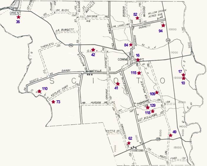
Cemetery locations were marked on this map according to maps in the County Recorder's Office which were drawn up by W.P.A. workers in the 1930's.
Those maps are not completely reliable as to exact distances, names of cemeteries, etc. However, this will be a reasonably reliable guide until we can get all the cemetery markers copied and locations pinpointed.
Bear in mind that several of these old cemeteries were moved to larger active cemeteries. Also, that in many instances individual families had a family member moved to their lot in another cemetery.
Some of the roads which were then (in the 1930s) township roads (T) have now been taken over by the county (C). However, only the prefix letter has been changed. The road number stayed the same. Township roads are shown on the map with dashes; County roads are shown with solid lines.
Most of the Pickaway County Cemeteries have been copied by Historical Society members and are on file at the Pickaway Co. Genealogy Library.
|
Locater No. |
|
|
|
| 10 | Borror, Jam. Farm | Scioto | .9 m South S.R. 762; .5 m East S.R. 104 |
| 16 | Burnley | Scioto | .2 m East T-140; North side S.R. 762 |
| 17 | Caldwell Farm | Scioto | .8 m South S.R. 762; .5 m East S.R. 104 |
| 36 | Feeble Minded Institute | Scioto | .3 m South S.R. 762; 1 m East C-26 |
| 41 | Gochenour | Scioto | .5 m West C-4; 2.5 m North T-147 |
| 42 | Gochenour North | Scioto | .5 m East T-33; .8 m North C-22 |
| 49 | Hall, Bill Farm | Scioto | East side T-136; 500 ft. North S.R. 316 |
| 52 | Haughn-McCord | Scioto | .4 m East T-142; .3 m North T-140 |
| 62 | Hott (Geo.) Farm | Scioto | 385 ft. East T-148; .3 m North S.R. 316 |
| 73 | Kepler Ford | Scioto | 1.3 m West C-33; .1 m South T-170 |
| 84 | Methodist | Scioto | West side T-140; .6 m North S.R. 762 |
| 94 | McCord Farm | Scioto | .2 m West S.R. 104; 1.5 m North S.R. 762 |
| 109 | Peters Farm (Press) | Scioto | .4 m North T-138; .1 m West T-136 |
| 110 | Phillips-Lamb | Scioto | .4 m South T-22; 2 m West C-33 |
| 115 | Presbyterian | Scioto | West side T-138; .6 m South S.R. 762 |
| 118 | Reed | Scioto | .5 m East C-4; .5 m North T-137 |
| 129 | Sample | Scioto | .4 m South of intersection of T-139 & T-138 |